


There are places in the world that resist description not because they are beyond language but because language, confronted with them, suddenly feels like the wrong tool entirely. The Faroe Islands — eighteen volcanic outcrops rising from the North Atlantic midway between Norway and Iceland, home to roughly 55,000 people and approximately 80,000 sheep — are one of those places. Photographs of them circulate endlessly on social media, gathering hundreds of thousands of saves and shares from people who have never been and may never go, because even a photograph, flattened and lit and cropped for a screen, cannot quite explain what makes the Faroes so extraordinary. The cliffs are not merely tall — they are the kind of tall that makes your legs feel strange when you stand at their edge. The sea is not merely rough — it is a living, muscular, genuinely indifferent force that has been shaping these islands for sixty million years and will continue doing so long after every human who ever stood on their shores has been entirely forgotten.
The Faroe Islands sit 320km north of Scotland, 655km west of Norway, and 450km southeast of Iceland — an autonomous territory of Denmark with their own language, flag, parliament, and one of the most distinct cultural identities in the North Atlantic world.
The geology that created the black beaches
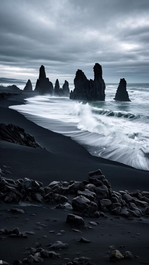
The black sand beaches of the Faroe Islands — most dramatically at Sandvík on the island of Suðuroy, and along the wild northwestern coasts of Vágar and Streymoy — are a direct product of the volcanic geology that built these islands sixty million years ago, during the same period of massive basaltic eruptions that also formed Iceland, Greenland’s eastern coast, and the Scottish island of Staffa. The black sand is not sand in the conventional sense but finely pulverised basalt — ancient lava rock ground down over millennia by the extraordinary force of the North Atlantic, which arrives at these shores having travelled uninterrupted across thousands of kilometres of open ocean and carries an energy that is visible, audible, and physically felt in the chest. The result is a coastline of dramatic contrasts: jet-black beaches hemmed by cliffs of layered dark basalt, topped with grass so intensely, impossibly green — a product of the near-constant moisture and mild temperatures that the Gulf Stream provides — that the colour seems digitally enhanced even when seen with unaided eyes. This is not landscape as backdrop. It is landscape as argument — a sustained, geological case for the sublime.
Trælanípa and Sørvágsvatn — the lake above the ocean
No single landscape feature in the Faroe Islands has captured the world’s collective imagination more completely than the optical illusion of Sørvágsvatn — a lake on the island of Vágar that, when photographed from a specific point on the cliff above it, appears to float suspended above the surface of the ocean far below. The illusion is a product of elevation and perspective: the lake sits at approximately thirty metres above sea level, while the cliff from which it is photographed drops dramatically to the sea, creating the appearance of a body of fresh water hovering impossibly over the Atlantic. The hiking trail to the viewpoint at Trælanípa — a two-hour round trip across open moorland in weather that changes from sunshine to horizontal rain within the same ten minutes — is one of the most rewarding walks in the North Atlantic, and the view from the cliff edge, illusion or not, is among the most genuinely vertiginous and arresting things a human being can stand in front of. The sheep graze calmly at the cliff edge, entirely unbothered by the drop, which tells you something about the difference between the Faroese relationship with this landscape and everyone else’s.
“The Faroe Islands do not perform their beauty for you. They simply exist — ancient, indifferent, and magnificent — and leave it entirely up to you whether you are equal to what they are offering.”
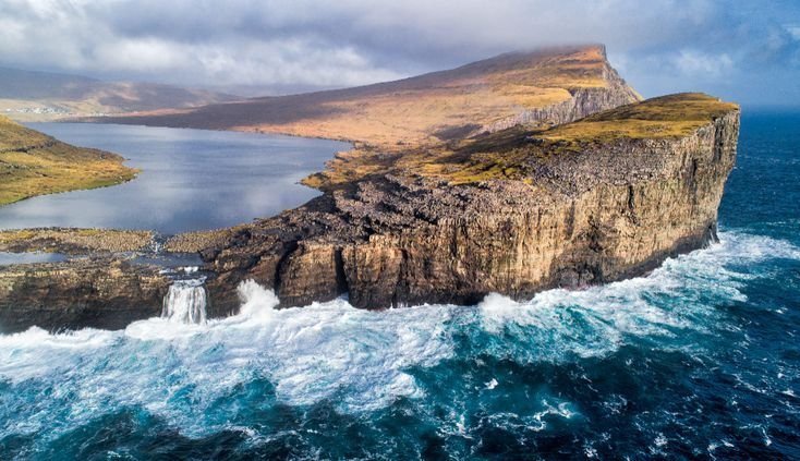
Gásadalur and the waterfall that falls into the sea
Before 2004, the village of Gásadalur on the island of Vágar was accessible only by a steep mountain pass that required a fit adult approximately two hours to traverse on foot. In 2004 a tunnel was bored through the mountain, connecting the village — population: approximately fifteen people — to the rest of the island by road. It is, by any objective measure, one of the most disproportionate infrastructure investments in the history of European civil engineering, and it produced one of the most visited viewpoints in the Faroe Islands: the Múlafossur waterfall, which plunges directly from a cliff above Gásadalur into the ocean below, with the village’s handful of turf-roofed houses arranged in the middle distance against a backdrop of open Atlantic that stretches, visibly and without interruption, all the way to the horizon. This is the image most people carry in their minds when they think of the Faroe Islands — the waterfall, the village, the sea — and it is one of those rare cases where the reality is considerably more powerful than any photograph of it has ever managed to convey.
What the Faroe Islands demand of the traveller
The Faroe Islands are not a destination that rewards passivity. The weather — which combines the climatic influences of the North Atlantic, the Arctic, and the Gulf Stream in a pattern that produces all four seasons in the course of a single afternoon — requires flexibility, layering, and a genuine willingness to have your plans comprehensively rearranged by forces entirely beyond your control. Hiking trails that are marked on maps may be closed due to ground conditions. Ferries between islands operate according to schedules that the sea treats as suggestions. The famous puffin colonies that nest on the cliff faces from April to August are accessible only to those willing to sit quietly at a clifftop for long enough that the birds forget to be alarmed. The Faroes ask you to slow down, to wait, to accept that the landscape operates on its own timeline and that the most extraordinary things it offers — a break in the clouds that turns a grey moorland suddenly, briefly golden; a wave that detonates against a basalt stack with a force that leaves you temporarily unable to speak — cannot be scheduled or guaranteed or optimised. They can only be witnessed, by the traveller who showed up and stayed long enough to be in the right place when the island decided to reveal itself.
The edge of the world, and why it matters
The Faroe Islands sit at the very outer boundary of the habitable North Atlantic world — north enough to feel genuinely remote, south enough to sustain a civilisation that has been continuously inhabited since Norse settlers arrived in the ninth century and found, to their considerable surprise, that Irish monks had got there first. What those early inhabitants understood, and what every traveller who makes the journey there today eventually comes to feel, is that living at the edge of something — at the boundary between the domesticated world and the genuinely wild one — produces a particular quality of aliveness that more comfortable places simply cannot replicate. The black sand beaches of the Faroe Islands are beautiful in the way that only truly indifferent natural forces can make something beautiful — without intention, without audience, and without the slightest concern for whether anyone is watching. That quality, in a world where almost every landscape has been curated for consumption, is rarer and more valuable than almost anything else travel currently has to offer.